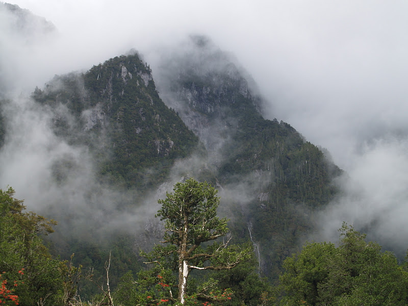
We drive
then clamber through a forest of skeletons to reach ground zero: flattened
trees, decapitated trunks, all-consuming silver-grey ash and rock debris, with
a seething mountainous blister backdrop – the Chaitén volcano. Its steam and
pervasive eggy smell foretell a still angry volcano god, but scientists assert
he is gradually calming down after his 2008 eruption that affected life in this
part of the world so much. I’ve never seen anything like this before and
struggle, in awe, to imagine what it must have been like here meeting the
catastrophic force with the power to snap a four-foot tree trunk like a corn
stem.
 |
| On the Carretera Austral approaching the forest of skeletons in the distance |
 |
| Volcan Chaiten steaming angrily in the background |
This
vista and the drive to get here reinforces in my mind that Patagonian Chile is
a geological contortion of immense proportions – a union of geo-forces that
contrive a unique landscape – tectonics, volcanoes, wind, rain, sea, ice and
snow, and biology. It’s raw, wild, isolated, and spectacular and the people who
live here remain at the mercy of these elements, despite their attempts to
civilize the land.
 |
| Return of the Nalca |
Back by
the blister in the forest of skeletons, we walk along the new trail being
developed by Carlos’ team that will eventually take hikers to the edge of the
rusty, steaming dome above us. Among the grey ash and white wooden bones,
patches of green re-affirm nature’s own restorative powers without the need for
our helping hand. A fern here, a fuchsia there and, most surprisingly to my
Cornish garden eyes, gunneras everywhere. Gunneras, iconic garden plants of the
country homes of the Cornish gentry, are sprouting everywhere. In Chile they’re
called
nalcas and there’s a range of
different species. Here their leaf stalks used to be eaten in salads or made
into marmalades.
The
Chaitén eruption forced the closure of the popular southern part of Pumalin
Park for three years as roads were blocked for miles with fallen trees and
assorted mineral debris. They have only very recently been re-opened and Carlos
is hoping that this summer will see visitor numbers increase. After motoring
through forests shadowed by ice-capped mountains and passing reflective lakes,
we arrived at the beautifully-appointed El Volcáns camp-site on the flat valley
floor of the Rio Rayas, which has just been restored to its former glory after
the eruption. It was originally built on a site devastated by poor forestry
practices; now, the new buildings and camp-site shelters continue the Pumalin
design tradition that I am coming to expect. The camp-site will re-open in the
next few days
The regional town of Chaitén was almost erased from the map as the eruption smothered buildings and roads under several feet of volcanic ash, transforming the local geography. The authorities did a sterling job evacuating the population – apparently no-one died – but in the aftermath wrote the town off. Today, over three years since the earth burped, the local geography remains transformed: the beautiful bay is now a new delta of volcanic debris, the town’s river sports the skeleton of a fragmented timber building and many others remain half buried with grey ash. Rows of empty homes and businesses tell that many residents did not return; those that did seem to be slowly turning the volcanic tide. Tourist accommodation is increasing, reflecting the main economic driver based on the surrounding natural splendour. And all the time, the volcano, one of three in the immediate vicinity, steams ominously to the north at the head of its eponymous valley.


 |
| Another skeleton forest - view from the back |
El
Amarillo is a small, roadside village at the south entrance to Pumalin Park,
where we stop for lunch. Then Carlos, Irwin – the head of this sector of the
park – and I head up the valley to hike a new trail being constructed to an old
camp site. Irwin and Carlos are evidently used to this kind of uphill hiking
thing as the distance between them and me gradually lengthens, making me feel
like I’m walking backwards – I use the excuse that I keep stopping for photos!
The trail up is beautiful and courses by the side of the fast-flowing,
turquoise Rio Amarillo. As we increase in altitude through the forest, volcanic
ash grades from a light dusting to a two-foot coating and the trees around us
turn from vibrant spring leaves to silver-grey standing dead – the day’s second
skeleton forest. We are a few miles southwest of the Chaitén volcano, but it’s
hidden behind an intervening mountain. However, we do have spectacular views of
its larger volcanic neighbour, Volcán Michimahuida, with its permanent ice cap
and tumbling glaciers. Michimahuida is less explosive that its recently
eruptive companion as its more fluid basaltic lava flows rather than explodes;
it is this black rock that the river is slowly eroding.
We reach
the top of the hill, in the middle of a post-apocalyptic volcanic wasteland, to
suddenly happen upon a surprisingly fresh, green field. My first (speechless)
reaction is ‘golf course’ – incongruous as it appears, until Irwin explains
that this is a very recently restored camp site that was inundated under metre
of ash when Chaitén let rip. His team has just finished removing and leveling
the ash and planting new grass. They intend it to be open for the first time in
three years within a fortnight.
 |
| View from the restored camp site: Volcan Michimahuida and one of its glaciers |
 |
| Gulley in place of the original path |
The path
we have just walked up is also the way down; however, Irwin is keen to show us
the old path that is no longer usable after the damage inflicted by Chaitén. We
pick our way through an arboreal obstacle course of fallen trees and use thin
trunks as improvised bridges to cross four metre deep, blackened gullies where
the path once ran. Quite exciting but, darn it, I just can’t keep up with those
boys!
 |
| Hidden path |
A couple
of hours later after a quick drive back, I am in Pumalin’s excellent Caleta
Gonzalo café. Carlo and his wife, as usual, serve me scrumptious, home-cooked,
local food. It’s getting dark outside and will be a much cooler night than of
late. The local ferry has just broken down causing a queue of waiting vehicles
up the slipway. Their occupants – people of all ages – are huddling around the
welcoming, crackling wood fire in the corner of the café so, for once, I am not
eating alone.
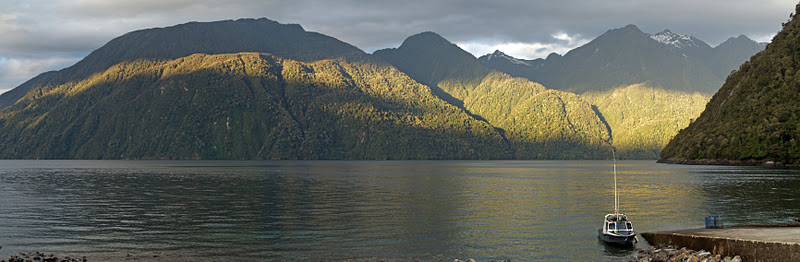 |
| Last night: Renihue Fjord from Caleta Gonzalo |
Tonight
is my last night in Pumalin Park. Tomorrow I venture south on a long road trip
along the Carretera Austral with two people I don’t know, for several days of
who knows what experiences in the wild wilderness of Patagonia. Bring it on!

No comments:
Post a Comment