Saturday 31 December 2011

Pumalin Park, Patagonia. Part 2: Volcano


We drive then clamber through a forest of skeletons to reach ground zero: flattened trees, decapitated trunks, all-consuming silver-grey ash and rock debris, with a seething mountainous blister backdrop – the Chaitén volcano. Its steam and pervasive eggy smell foretell a still angry volcano god, but scientists assert he is gradually calming down after his 2008 eruption that affected life in this part of the world so much. I’ve never seen anything like this before and struggle, in awe, to imagine what it must have been like here meeting the catastrophic force with the power to snap a four-foot tree trunk like a corn stem.


On the Carretera Austral approaching the forest of skeletons in the distance


Volcan Chaiten steaming angrily in the background

This vista and the drive to get here reinforces in my mind that Patagonian Chile is a geological contortion of immense proportions – a union of geo-forces that contrive a unique landscape – tectonics, volcanoes, wind, rain, sea, ice and snow, and biology. It’s raw, wild, isolated, and spectacular and the people who live here remain at the mercy of these elements, despite their attempts to civilize the land.


Return of the Nalca
Back by the blister in the forest of skeletons, we walk along the new trail being developed by Carlos’ team that will eventually take hikers to the edge of the rusty, steaming dome above us. Among the grey ash and white wooden bones, patches of green re-affirm nature’s own restorative powers without the need for our helping hand. A fern here, a fuchsia there and, most surprisingly to my Cornish garden eyes, gunneras everywhere. Gunneras, iconic garden plants of the country homes of the Cornish gentry, are sprouting everywhere. In Chile they’re called nalcas and there’s a range of different species. Here their leaf stalks used to be eaten in salads or made into marmalades. 


The Chaitén eruption forced the closure of the popular southern part of Pumalin Park for three years as roads were blocked for miles with fallen trees and assorted mineral debris. They have only very recently been re-opened and Carlos is hoping that this summer will see visitor numbers increase. After motoring through forests shadowed by ice-capped mountains and passing reflective lakes, we arrived at the beautifully-appointed El Volcáns camp-site on the flat valley floor of the Rio Rayas, which has just been restored to its former glory after the eruption. It was originally built on a site devastated by poor forestry practices; now, the new buildings and camp-site shelters continue the Pumalin design tradition that I am coming to expect. The camp-site will re-open in the next few days


The regional town of Chaitén was almost erased from the map as the eruption smothered buildings and roads under several feet of volcanic ash, transforming the local geography. The authorities did a sterling job evacuating the population – apparently no-one died – but in the aftermath wrote the town off. Today, over three years since the earth burped, the local geography remains transformed: the beautiful bay is now a new delta of volcanic debris, the town’s river sports the skeleton of a fragmented timber building and many others remain half buried with grey ash. Rows of empty homes and businesses tell that many residents did not return; those that did seem to be slowly turning the volcanic tide. Tourist accommodation is increasing, reflecting the main economic driver based on the surrounding natural splendour. And all the time, the volcano, one of three in the immediate vicinity, steams ominously to the north at the head of its eponymous valley.


Another skeleton forest - view from the back
El Amarillo is a small, roadside village at the south entrance to Pumalin Park, where we stop for lunch. Then Carlos, Irwin – the head of this sector of the park – and I head up the valley to hike a new trail being constructed to an old camp site. Irwin and Carlos are evidently used to this kind of uphill hiking thing as the distance between them and me gradually lengthens, making me feel like I’m walking backwards – I use the excuse that I keep stopping for photos! The trail up is beautiful and courses by the side of the fast-flowing, turquoise Rio Amarillo. As we increase in altitude through the forest, volcanic ash grades from a light dusting to a two-foot coating and the trees around us turn from vibrant spring leaves to silver-grey standing dead – the day’s second skeleton forest. We are a few miles southwest of the Chaitén volcano, but it’s hidden behind an intervening mountain. However, we do have spectacular views of its larger volcanic neighbour, Volcán Michimahuida, with its permanent ice cap and tumbling glaciers. Michimahuida is less explosive that its recently eruptive companion as its more fluid basaltic lava flows rather than explodes; it is this black rock that the river is slowly eroding.


We reach the top of the hill, in the middle of a post-apocalyptic volcanic wasteland, to suddenly happen upon a surprisingly fresh, green field. My first (speechless) reaction is ‘golf course’ – incongruous as it appears, until Irwin explains that this is a very recently restored camp site that was inundated under metre of ash when Chaitén let rip. His team has just finished removing and leveling the ash and planting new grass. They intend it to be open for the first time in three years within a fortnight.


View from the restored camp site: Volcan Michimahuida and one of its glaciers


Gulley in place of the original path
The path we have just walked up is also the way down; however, Irwin is keen to show us the old path that is no longer usable after the damage inflicted by Chaitén. We pick our way through an arboreal obstacle course of fallen trees and use thin trunks as improvised bridges to cross four metre deep, blackened gullies where the path once ran. Quite exciting but, darn it, I just can’t keep up with those boys!


Hidden path

A couple of hours later after a quick drive back, I am in Pumalin’s excellent Caleta Gonzalo café. Carlo and his wife, as usual, serve me scrumptious, home-cooked, local food. It’s getting dark outside and will be a much cooler night than of late. The local ferry has just broken down causing a queue of waiting vehicles up the slipway. Their occupants – people of all ages – are huddling around the welcoming, crackling wood fire in the corner of the café so, for once, I am not eating alone.

Last night: Renihue Fjord from Caleta Gonzalo

Tonight is my last night in Pumalin Park. Tomorrow I venture south on a long road trip along the Carretera Austral with two people I don’t know, for several days of who knows what experiences in the wild wilderness of Patagonia. Bring it on!

Wednesday 28 December 2011

Forest Colossi


About 15 minutes’ ripio drive from Caleta Gonzalo, aside the Carretera Austral, is a magical forest of bejeweled, green giants giving a rare glimpse of how much greater the still spectacular Valdivian rainforest once was.


The Alerce pine is among the world’s oldest and most massive living things. These remarkable trees (see last blog) were once common over thousands of square miles of Patagonia; today, Pumalin Park retains about 25% of the world’s population. The Alerce Trail, along which Carlos and I are hiking, traverses the translucent, tumbling river that drains the surrounding mountains, swollen by yesterday’s heavenly outburst (today’s broken cloud and patchy blue sky are a welcome relief). I feel like a mouse crawling through a corn field as the trail weaves us around stout, towering columns in the domain of giants. The Alerces, festooned with moss, ferns and other hanging greenery, sparkle like a million fairy lights as yesterday’s captured raindrops glint in shafts of sun. Their fibrous, red-brown bark coating trunks of massive girth is similar to that of California’s sequoias, as is their slow rate of growth. Alerce timber has been sought after for decades causing the rapid decline of these trees. Their regeneration on surrounding hillsides has been stymied by frequent forest fires as witnessed by their denuded, white skeletons, frozen, grasping for the sky above the surrounding southern beeches. Thankfully the protection and restoration afforded by Pumalin’s dedicated people means that, in patches, the Alerce forest is gradually returning.


Uplifted on leaving the impressive Alerces we continue south along the Carretera Austral, Carlos pointing out features of interest on the way. Although the park is private land the Carretera running through it is a public road and, as the authorities maintain the road, they lack care over restoring the natural aesthetic and leave linear, eroding scars of bare soil and uprooted trees that line the road for miles through the wilderness. A contrast to the elegant forest experience that I have just had; come on Chile, you can do better than that!

Saturday 24 December 2011

Pumalin Park, Patagonia. Part 1: Rain

Happy Christmas to all you fine people, wherever you are, and a big, festive thank you for taking the time to read my blog!

Now I know how a fairy feels atop a Christmas tree, sort of! The key differences, other than gender, being that I’m dressed from head to toe in sodden, black waterproofs and the tree on which I’m perched has neither branches nor leaves (although it did once). I’m on the lower slope of a high mountain, surrounded by a young forest of bright-leaved, Southern Beech trees emerging through the fallen, weather-bleached, wooden skeletons of their parents. The weather has changed completely from yesterday’s endless blue skies to an all-enveloping, sombre spectrum of muted greys, heavy clouds roofing the misty fjord down to the slatey sea at the mouth of the U-shaped Vodudahue Valley. It’s raining – lordy is it raining! This coastal part of Chilean Patagonia receives seven metres of rain per year and it all appears to be arriving at once – today. My waterproofs lived up to their name for less than ten minutes – and that was three hours ago! The torrential rain greases the inclined log on which I’m teetering, but the view along the valley in this small part of Pumalin Park is stunning nevertheless.

Vodudahue river in the pouring rain
Carlos and the farm from the top of my perch
I am accompanied by Carlos, the Head Guard at Pumalin Park, who is generously giving me a two-day tour of landscape restoration work around the park. First stop is Vodudahue Farm, one of several around the park. Geography makes even short distances here an adventure; the few kilometres from my Caleta Gonzalo cabaña involved two boat rides and a short stretch of ripio, followed by a two-kilometre drive on a tractor trailer! During an early engagement in our respective languages, with rain dripping off the ends of our noses, we agree a bilingual approach; Carlos talks in English to practice my native tongue, I speak in Spanish to enhance his. During the damp walk through the farm and the tricky scramble up to our current vantage point, Carlos and I discussed the purpose and the work of the tree nursery which raises native trees to restore the surrounding rainforest, and the fruit farm where a range of berries are grown, including the delicious, native murta. From our hill-side viewpoint Carlos points out the neat rows of the tree nursery, the restored and well-maintained farm tracks and the red-roofed, timber farm buildings reflecting the predominant reds and browns of the rainforest in the architectural mind’s eye of their designer.


Soaked!

Rainforest colour in the gloom

Pumalin extends over 1,200 square miles of Chilean fiords and mountains, blanketed in seemingly endless Valdivian temperate rainforest and home to spectacular animals, large and small, such as the puma and the humming bird. The names of the park and its top predator imply an etymological link, reinforced by their combination in the park logo, but Carlos explained that Pumalin, in the indigenous language, is a dry piece of land between wet areas, whereas puma is, er, a big cat! The park is nationally protected, but privately-owned by the Conservation Land Trust (CLT) – a charity set-up by Doug Tompkins to acquire and preserve important wilderness areas. He also lives locally, in fact, a few kilometres around the corner by boat! The fascinating story of the man, his wife (Kris Tompkins) and their work is described a million times on the internet, so I won’t go into too much detail here. Suffice it to say that I am now immersed in it, and will be for the next two weeks, and the results are exemplary and world class.

Before the park the land was not protected and, as over vast areas of Patagonia, the flatter valley floors and less steep valley sides were converted to cattle and sheep farms by pioneers during the 20th century, which involved clear-cutting and setting fires to clear the densely forested land. Millions and millions of hectares of land were cleared in this way – sometimes the fires burning unchecked for months. The fragile forest in areas not blessed with land good enough for agriculture was logged extensively for valuable timber trees such as the Alerce pine – the Patagonian equivalent of California’s spectacular redwoods in both size and age. They were extracted, damaging the surrounding forest and depleting much of the Valdivian temperate rainforest of these impressive arboreal giants.

Carlos with Alerce saplings
When Vodudahue was originally acquired it was a depressing economic and environmental disaster area, over-grazed by sheep and cows, crumbling riverbanks, broken fences, pot-holed and eroding roads, dilapidated buildings and degraded forests with no chance of regeneration given the intense grazing regime and frequent fires. Today, the farm is organic and produces berries, native trees and the most delicious honey I have ever tasted. It also farms horses and the aim is for these to become working horses. Farm products are sold throughout the CLT-owned properties in Chile and in various shops in the towns scattered widely through southern Chile. A new programme is being developed for visitors to Pumalin Park to sponsor an Alerce pine sapling to raise funds to restore these already impressive forests to their former magnificence.

On the return from Vodudahue, at the end of the day, it is still raining and still grey. Carlos invites me into his cozy house at the restored Pillán Farm, in the next valley along (which involves rides on a tractor, boat and truck), where I am introduced to his wife and we share coffee and chocolate (two dietary staples of mine). Pillán also serves as one of the main office areas for the Pumalin Park. The isolation and rugged terrain impedes communications – both physical and electronic – so each sector of the park has its own office and workshop infrastructure. The Pillán workshop originally provided the finely crafted furniture of my cabaña and all made from local wood.


Boat taxi

Tractor taxi

Already, from my experiences of Pumalin’s buildings in Puerto Varas, Caleta Gonzalo, Vodudahue and Pillán, I can see that great effort is expended on creating a homely architectural and interior design style that speaks a common language through and around the scattered settlements and restored buildings of the park. It’s a language of local, natural materials, attention to detail and quality, and a rusticity adapted from the American wilds, with a hint of a Shaker accent. Geographically, I feel lost in the middle of nowhere; geography and design meet awkwardly here at first experience, particularly in my already overwhelmed head, but with increasing exposure they combine creating a unique sense of place – simultaneously welcoming and wild!

Carlos' house

A restored building at Vodudahue farm
My cabana

Back in my cabaña after a long, damp day, I hang my dripping clothes around the small, electric radiator powered by a micro-hydropower turbine in a nearby mountain stream. The turbine’s oscillations cause a cyclical flickering in my low wattage, bed side light bulb. The rustic interior walls of un-planed timber, some with residual bark, create a relaxing texture with the mellow light as I settle for the night. It just feels right.

Tomorrow, Carlos and I will be heading deeper into the park. I hope by then my clothes will be dry. Read about it in the next blog.

Tuesday 20 December 2011

Welcome to Patagonia

Poor picture of a lovely, restored building, the Pumalin Park HQ in Puerto Varas
I’ve become utterly disorientated and am struggling to determine what happens next after three days of travelling from Brazil’s central Amazon to the northern tip of Chilean Patagonia, compounding the intense experiences of the previous five weeks. I manage to hold it together enough to get to my accommodation for the night – the head office of the Pumalin Park - soon to be a new national park, in Puerto Varas. It’s late evening. My patient, kindly airport taxi driver allowed me to practice my Spanish on him as I have spent the last two weeks in Portuguese-speaking Brazil, which has returned my Spanish to square one again.

There to welcome me at the Pumalin Park office are Maria and Carolina, who has helped me make the necessary arrangements for the next section of my journey. Maria shows me around the impressive, homely building; it’s a huge, century-old, wooden house that has been restored to a high quality and with attention detail, but with a simple design. Natural materials, particularly wood, dominate and the new floorboards creak reassuringly. The refit may be recent, but the furniture is old and chunky and emits a bees’ wax scent that pervades the building. Hanging from any wall space large enough to accommodate them are impressive black and white photographs of Patagonia’s wildlife and scenery, framed in black wood. It’s a mind warp after Brazil's Amazon, but it’s a style that will become familiar and the stunning photographs dictate scenes in which I will be immersed for real in the very near future.


Carretera Austral and that funky duck!
In less than eight hours I am on the road again, waiting at the unwelcoming Puerto Montt bus station, the sun just rising and burning through the early sea mist releasing distant mountains to view. There are a couple of scruffy blokes and some stray dogs, one of which growls at a passer-by; the growl becomes a yelp after a well-aimed kick by one of the scruffy blokes. I wait with some trepidation as I’m not a big fan of long bus journeys and this one should take around 10 hours. It’s a small bus with tiny seats, but, thankfully only half full. We set off along a paved road for a few miles before it mutates to ripio (gravel road) and begins winding around a forested coastline. That will be the last paved road that I will see for some days and for a couple of hundred kilometres. A fluffy, yellow, toy duck swings in the windscreen, right in my line of sight, specially designed to test my good humour. The road we are on is renowned in Latin American travel lore; it’s the southern Chilean end of the Pan-American Highway (except it doesn’t really feel like a highway, or even a road) and is called the Carretera Austral. Over the next 10 days or so I am to become very well-acquainted with the Carretera.


Through the bus window I begin to notice wild plants familiar from my own garden and from my days at the Eden Project and its beautiful Wild Chile exhibit. Chilean Fire Bush is in full crimson bloom as are the fuchsias and the gorse – yes, the golden pride of Cornwall persists here as an introduced pest plant! We pass occasional, coastal salmon farms and sparse groups of small wooden houses surrounded by recently cleared patches of the forest. You can tell the houses are new – the corrugated metal roofs are still silvery and shiny. We wind southerly onwards flanked by steep mountains to the east, sea to the west.


Just as the ripio rattling of my body starts to affect my brain, we arrive in the tiny coastal village of La Arena nestled between a steep valley and the sea, wood smoke rising from metallic chimneys tainting the air with that familiar, homely scent. A growing queue of cars and trucks waits at the top of a concrete ramp at the other end of which are two orange ferries in the style of military landing craft. We are still waiting an hour later and I’m getting hungry since I missed breakfast and an evening meal last night. At that moment, a small local food angel jumps onto our stationery bus to dish out hot empanadas (like a small Cornish pasty, but without the Cornish) from a large polystyrene box under her arm, and sugary, black coffee from a Thermos flask.

La Arena. Our bus, the Kemelbus, is at the top of the ramp

Waiting for the tide to rise!

I wonder what we are waiting for – there are two ferries and plenty of customers. Jokingly I ask a chap in the local café if they are waiting for the tide to rise; and actually they really are. Since a recent earthquake changed the height of the land in relation to the sea around here, the jetty/ramp is now at the wrong depth at low tide ( I was given two versions of this story: some say the land rose relative to the sea, while others say it fell. They can’t both be right!).


Leaving La Arena
Someone decides somehow that the sea has reached the right depth and vehicular activity begins – at precisely the same moment that I have just bought a coffee, that I have to neck and burn my throat. Under the watchful eyes of the local sea lions vehicles are crammed onto the craft like sardines before we sail away around a spectacularly steep mountain headland that has evidently proved too much of an obstacle for local road builders. The caerulean sea is silky calm under a perfect blue sky. We traverse a deep sea fjord – the profound geological scar of a long melted glacier - and get our first glimpse of the high Andean peaks to the east.


On the other side we disembark and carry on ever southwards. Around every turn is a new vista of whatever combination of mountains, fjords, snow, forest, sea and isolated wooden shacks you care to imagine, and it’s all jaw-droppingly stunning – a view spoilt only by the incessantly swinging fluffy duck.


We emerge around a corner to the large village of Hornopiren at the foot of one of those cliched, but nevertheless impressive, snow-capped, conical volcanoes. From here we embark on a more substantial orange ferry for more than four hours of sailing to the next stretch of the Carretera. As we pull away from Hornopiren, the Hornopiren Volcano, which close-up seemed so high, appears dwarfed by the sugar-capped peaks behind, which till now had been obscured.

Hornopiren and its eponymous volcano

Cruising the line between forested mountains and islands, high waterfalls leap from precipitous, bare rock and hanging valleys tantalize with views of secret peaks. In the distance white splashes glinting in the bright sunlight indicate disturbance in the water. The disturbance moves closer until we can discern 20 or so dolphins porpoising towards us before veering off between our boat and the land and melting into the distance. Here and there, on the kinder gradients, the forest mantle has been removed and replaced with grass for cows and the occasional farm building. I wonder how anyone can make a living here; or do they just live?

Slow boat on the Pan-American Highway

On the ferry we have time to wander and chat with fellow passengers. I meet Lisi, an ecological economics professor from New York, who is travelling with Jane, a family friend and recent visitor to southern Chile. Lisi is also on her way to Pumalin Park to meet Doug and Liz, the brains behind the development of the park and many other exemplary conservation projects in southern Chile and Argentina and the main reason I am in this part of the world. On my whole journey I have met very few British people, but there are two on this ferry – Charlie and Jane – on a six-month backpacking tour of South America. They are now into month five and are also heading to Caleta Gonzalo. I also chat with a local Chilean about the area. He runs a tourist fly-fishing business on the majestic rivers further south. He explains that there are plans to replace this five-hour ferry journey – an experience of enforced relaxation and contemplation – with a new section of the Carretera bulldozed through the forests and mountains. His thought is that the most obvious and flexible way to increase capacity is to increase the number and frequency of ferries. Seems like a no-brainer to me!

Chasing the Sun on the boat to nowhere, with Lisi


Our large ferry pulls up onto a tiny ramp seemingly in the middle of nowhere. We disembark and drive up past the queue of diverse vehicles waiting to get on. I notice the first Pumalin Park signs, carved intricately from a mellow wood, at the Leptepu entrance. Another bumpy, dusty, fluffy-duck bouncing 20-minute drive later and we arrive at another in-the-middle-of-nowhere ramp into the sea. Another orange landing-craft takes us across another impressive fjord to a collection of five or six, single-storey wooden buildings, intimidated by the surrounding natural splendour, but cosily nestled at the top of a small delta beach. White wood smoke spiralling from the cabins promises a fine welcome and the end of 10 hours and 180 kilometres of ripio, sea and fluffy, yellow ducks.


Caleta Gonzalo, home for the next three nights

Tuesday 13 December 2011

Amazon Aluminium Part 2: Snake in a Box

Our small plane lands on Juruti's red dirt airstrip and shudders quickly to a standstill. I am met off the plane by Volnei in the dazzling light and baking heat of the midday sun. We bypass the little shed that passes as the airport terminal. Volnei and his team are to show me the restoration plans and work at ALCOA’s brand new Juruti bauxite (aluminium) mine.

Juruti airport. Baggage collection on the left; departure lounge on the right

Juruti is a small town that has existed on the banks of the Amazon for generations. Although the operating mine itself is only a couple of years old, ALCOA has been in the town for the past eight years to develop the mine. As a new mine Juruti has benefited from the experiences of other older operations, such as Trombetas, from where I have just arrived. A mine of the scale, value and longevity of Juruti will inevitably transform the surrounding region. In recognition of this, and in order to gain the necessary operational licenses, ALCOA has committed to working with other key organisations such as regional and local government agencies and surrounding communities to develop a system to ensure that the people who are to be most impacted by the mine, i.e. local people, have the most to gain from its presence. One early example of this is that, unlike at Trombetas and Carajas mines, all Juruti mine workers will live in the town and will become fully integrated members of the community. The mine has also built a brand new hospital and there are plans for other major community enhancement projects too.

It’s a 54 km drive through the jungle along a brand new tarmac road, between Juruti and the mine proper, following the railway line that transports bauxite from the mine to the port on the banks of the Amazon. There is virtually no traffic on the road. This drive must be done twice a day by all who work at the mine, meaning early mornings and late evenings for everyone.

I am taken to meet Volnei’s team, including Ellie, Susiee and Diego and, as usual, we subject each other to Powerpoint paraphernalia. After a surprisingly good lunch, considering we are in the middle of the jungle, we tour the mine site. The bauxite extraction method is essentially the same as that described for the much older Trombetas mine a couple of blog’s ago. Still, the scale of the operations, even at this early stage, is mind-blowing. We emerge from the forest road into an expansive moonscape, distantly bordered by the green wall of the jungle. Weaving around mechanical dinosaur mining machinery, we bump along the dirt roads of an expansive earthen scar under a bleached blue sky, heaps of yellow and red rock towering above us. Could this be what Mars looks like?


We arrive on the other side of the experience back on the edge of the Amazon jungle – or at least it had been the edge a few days ago. Now the forest is almost flattened: enormous trunks lay scattered, randomly like dropped matchsticks, as chainsaw rasping reverberates. We are here to see the wildlife rescue team in action, whose job is to scour the forest before clearance to remove slow-moving animals and save important plant specimens. We are shown a large wooden box the size of tea chest, upon which sits a smaller wooden box bound tightly with rope. The occupant of the latter is colloquially called sururucu - a three-metre long, venemous snake! The rescue chaps start opening the box to offer us a closer look, but I am more than satisfied to simply watch a video of the beast’s capture on a mobile phone. Scary looking thing! If that’s what's in the small box, then the occupant of the larger one must be truly terrifying. Despite my protestations they open it and lift out a very sleepy, three-toed sloth. I've never seen one before and as they hold it it slowly looks around with a bizarrely high-foreheaded human face and a fixed smile! Around and about, under a temporary awning, is a motley collection of smaller animals – lizards, frogs, etc. and tree seedlings – carefully extracted from the forest before their parents become flattened.


Forest in the process of being cleared, prior to mining


To my more than slight concern the snake in a box is put on the back of our vehicle for return to the site office where Ellie compounds our fears by donning safety gloves and snake-proof shin guards and tries to open the box in the kitchen. The look of complete horror on everyone’s faces, including mine, dissuades her, yet, conflictingly we all want to watch and are secretly disappointed that she doesn’t follow through. Sururucu will be sent to a snake research organisation in Belem, which will then return it to a safer patch of forest.

Susiee in her pilot tree planting area
Back on the mine I am shown the very first areas that will be re-planted at Juruti in the next few weeks. Once the forest has been cleared, the demarcation between forest and barrenness is as straight as the edge of an English country lawn, and shows up very well on Google Earth (see the map-cake link). Juruti are trialling a slightly different kind of forest re-establishment compared to Trombetas. Instead of simply spreading the topsoil in layer over the workings and planting trees, they are using a loose-tipping method in which piles of soil are tipped off the backs of trucks. The regular rain of the area then washes much of this down to cover the surrounding subsoil and then trees are planted. This method requires fewer heavy vehicle movements (no spreading) therefore reducing compaction, saving fuel costs and reducing greenhouse gas emissions. Also, the different soil depths provide more ecological niches for colonisation by other species. I was taken to a small pilot area where trees were planted less than three years ago and are already double my height with a closing canopy. Very promising.

It's late afternoon and I'm taken to Juruti to the room of my small, new hotel, literally on the bank of the Amazon. As sunset approaches I decide to explore the fascinating little town – a town that is on the verge of transformation. I am absorbed by the water-front where passenger boats sit, awaiting cargoes of people and products, hammocks at the ready, for shipping to who-knows-where in this riverine wilderness. There are people washing and fishing in the river and then returning to their boat homes, getting for the night, which drops like a shutter at this latitude.


Juruti river front

I wander the streets passing tidy shops with various acknowledgements that Christmas is around the corner, although tinsel and Santa seem seriously out of place given the surroundings. Four girls wearing pink, plastic roller-skates straggle uphill towards me on this sweltering equatorial evening. I’m heading down in the opposite direction. Street-side shops boom an unsolicited auditory backdrop of their own mediocre musical brands, merging as I stroll between them like the set-list of a useless D.J., and easily out-performing the squabbling birds roosting in the mango trees. Rivulets of human effluent flowing down the street, as in most Amazon towns, occupying the olfactory sense – my flip-flops aren’t the ideal footwear here! I reach the river front, far enough from the music for it not to distract, as the sun is setting. Clouds obscure the spectacle somewhat, but it’s the setting that matters: I’m in Juruti, the hill is a river bank, and the river is the biggest in the world – the Amazon – and I’ve finally realized a childhood dream.

Later that evening, I am picked up by Volnei and family and, with the rest of his team, sit in a basic restaurant at the side of a dark street. The barbecued Amazon fish is the best that I have ever tasted and washes down well with the local beer. I go to bed satisfied and relaxed.

Ellie with tree seedling
The next morning we pay a quick visit to the germinal Juruti tree nursery. Health and safety policy dictates that I have to wear a straw hat as sun protection, although it fits my head in the same way an upturned egg cup would. Although some tree seedlings are growing, the site is still being developed; a recently discovered archaeological site will be preserved and incorporated as part of the nursery’s educational mission. I am taken to view the small herb and vegetable garden at the risk of being hammered in the head by hard, green mangos which gravity extracts from the large, over-hanging tree, hitting the floor within a couple of feet of us with a dull thud. I have little faith in the cranial protection offered by my egg cup straw hat.


Awaiting a mango hammering!

I am then driven to the short, red dirt airstrip to fly back to Santarem. I arrive with about 20 minutes to spare, but this is not Heathrow, everyone is chilled and no-one even asks me for ID. I opt to wait outside in the shade of a wing rather than in the tin shed on offer as the airport building. I know that if/ when I return here in a couple of years’ time this will have all changed. There are serious plans to build a tarmac runway to take jet planes and a proper airport building where you will sit in an air-conditioned room and stare through a window - just like everywhere else.

The plane takes off and again I have views over the pilot’s shoulder as we aim for Santarem. It will take me the best part of three days and numerous flights, but I am now leaving the forest of my dreams and chasing the sun south to Patagonia.


Goodbye Juruti, so long Amazon; Patagonia here I come!
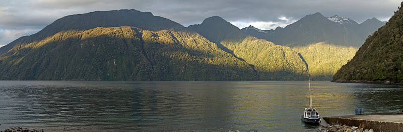
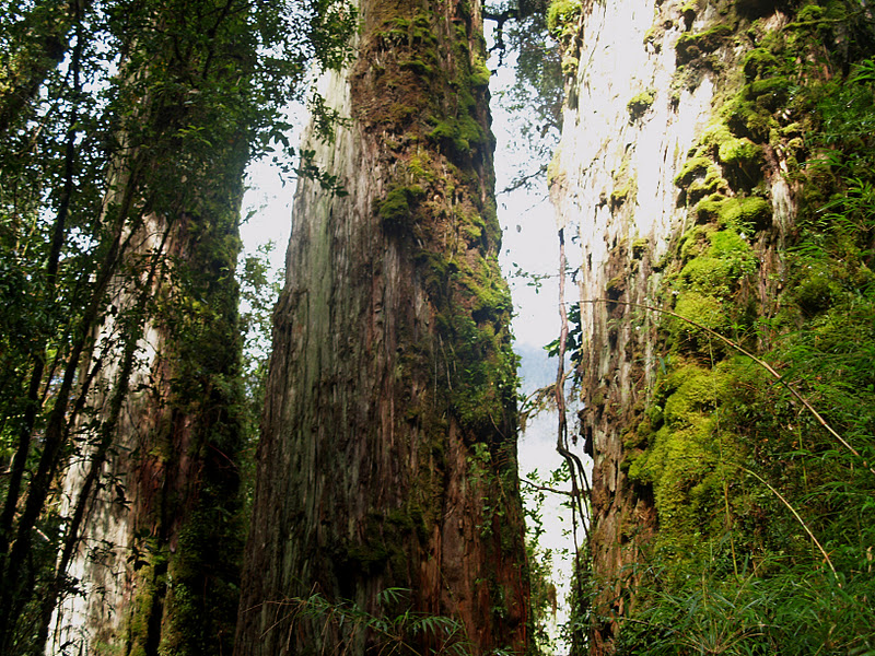
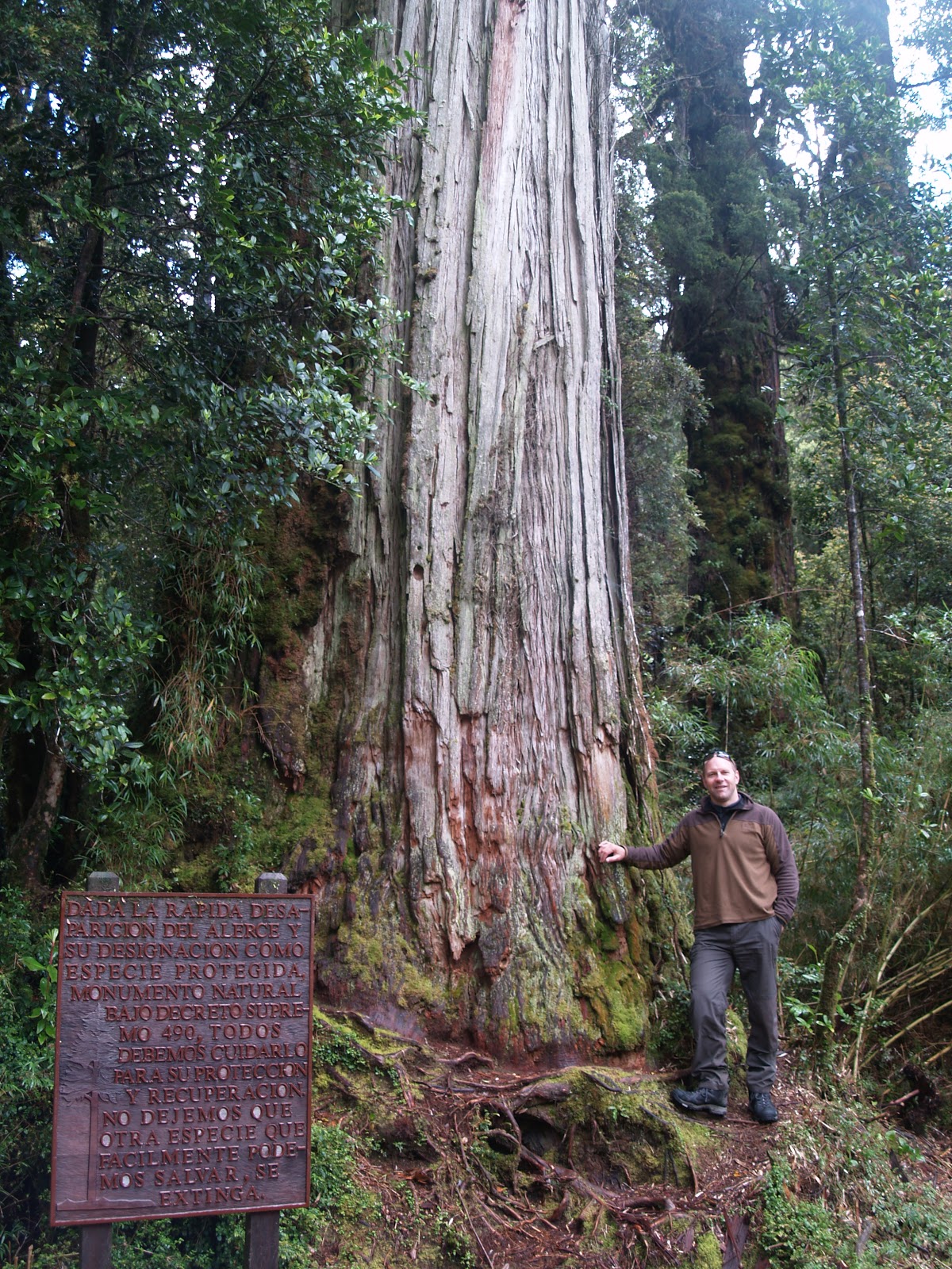
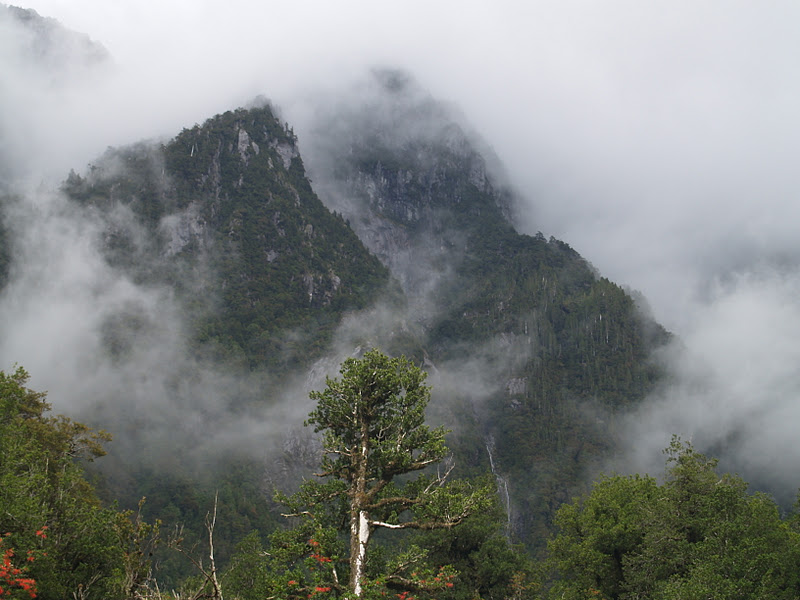
Monday 12 December 2011

Amazon Views

Belem, at the mouth of the Amazon
It’s an early start; a very early start! Planes are used in the Amazon much like the British use buses. To reach your intended destination typically entails a 4 a.m. take-off and three or four stops en route, while various people get on and off. The flights always appear to be full and the planes always appear to be new.


On this occasion, however, on my flight into Juruti from Santarem – the Amazon River’s third city after Belem and Manaus – I am on a (very) small propeller plane chartered by ALCOA (the multi-national mining company). Larger planes are unable to use Juruti’s short, red dirt airstrip. Flying low at only a few thousand feet, the early morning views are spectacular. The river near Santarem is approaching 60 kilometres wide and divides into a maze of channels and islands. The islands are painted every shade of green, shedding swirling, early river mist like smoke. Some are forested with white sandy beaches, such that you could be forgiven for believing you might be in the Caribbean. It’s also the place where the muddy, brown Amazon meets the dark, clear Rio Tapajos – the two waters flowing side by side for several miles before the mighty Amazon gradually, but inevitably, dominates.

Santarem Sunrise

Amazon Islands


Caribbean or Amazon?

Map reading?
Cruising at around 5,000 feet (I know this because I am sitting directly behind the pilot and am watching his every move over his shoulder), I become alarmed and think we may be lost when the pilot unfolds a road map; but instead of navigating by it, he places it over the windscreen to eclipse the blinding sun – good move – but I now wonder how he can see where we’re going!

Unfolding beneath us is the forest home of 20 million people – not necessarily the pristine wilderness we are often led to believe. Flying above it all, though, it’s hard to see where they all live. For hundreds of miles a patchwork quilt of green shades intimates the different stages of forest regrowth after fields have been left to naturally regenerate. Often, in the distance, a column of white smoke rises from another patch of clearance, although I reckon that much of this is simply the cleaning of overgrown fields rather than the burning of primary forest. Recently cleared areas are easily identified by their bare redness, often sporting tiny shacks, or the rows of young crops. Occasionally a thin red line snakes through the green, devoid of vehicles, and liquid snakes literally meander through the forest flashing diamond light, trading water for sediment and draining half a continent. From this altitude it’s like a secondary school geography lesson displaying every conceivable concoction of riverine features: meanders, ox-bow lakes, river cliffs, floodplains, deltas, and the rest. You know when you are flying over remoter areas when the green extends in every direction and becomes less a patchwork quilt, more an endless green blanket with the texture of a broccoli head.


Forest patchwork quilt


Forest broccoli blanket


'nuff said!
Snap back to reality! We are descending to a short, red dirt airstrip, surrounded by towering jungle trees rapidly rising to meet us; I need to check that the pilot is doing his job properly!