Showing posts with label Carretera Austral. Show all posts

Saturday, 7 January 2012

With Thelma and Louise on the Carretera Austral


After my final, home-cooked breakfast before the homey open fire in Caleta Gonzalo’s cozy cafe, I re-pack of my enormous sack – something at which I am now becoming adept. Leaving my cabaña for the last time I stumble across the rocky beach to welcome Lisi and Jane back onto dry land from their small boat from Reñihue. They are both American and they are accompanied by an affable Argentinian chap, called Rafa, and his wife (more of whom in a later blog). (Lisi, Jane and I first met briefly a few days ago on the ferry rides between where we are now and Puerto Montt – the origin of our Patagonian adventure.) With some trepidation I am about to embark on a journey into the unknown with two people I hardly know,  for several days within the tight confines of a Nissan X-Trail 4WD.

Caleta Gonzalo cabanas


Caleto Gonzalo cafe, with a garden of native plants

Carlo and his wife
I splutter Spanish goodbyes to Carlo and his lovely wife – the king and queen of Caleta Gonzalo and, together with Lisi and Jane, depart the fairytale settlement aiming south on the single-lane, gravel (ripio) Carretera Austral (also the southern end of the trans-continental Pan-American Highway). It’s a bright, sunny day as we motor through the forest and mountains towards Chaitén. We stop briefly at the Chaitén volcano trail that I visited yesterday with Carlos to show them the devastation down-slope of the still steaming volcanic blister (see last blog). We also hop out at Chaitén town for quick pics of half-buried houses. We stop for petrol at the pleasant little village of El Amarillo, at the southern gate of Pumalin Park. Here, park people are working with local home-owners to spruce up their buildings to enhance the area’s tourism potential. At the smart, new grocery store we stock up with essential supplies – chocolate, crisps, biscuits, Pumalin park honey, walnuts and more chocolate – and continue on our journey. Beyond El Amarillo and the gates of Pumalin we enter uncharted territory – a strange new world, boldly going where none of us have gone before.


Route of Carretera Austral through Pumalin Park; panorama over Lago Rio Negro


El Amarillo house after aesthetic improvements

Volcan Michimahuida + ice cap, from El Amarillo, with typical Pumalin farm fencing

The first few hours are relatively easy driving, considering that the Carretera is a single-lane gravel road. The road runs relatively straight along the long, narrow valleys of the Rio Yelcho and the Rio Palena, skirting the Corcovado National Park and its eponymous, perfectly conical volcano. Corcovado National Park is the outcome of another inspirational Conservation Land Trust/ Tompkins project.

Crossing the Rio Yelcho

The snow-capped cordillera funnels us southwards as isolated farm shacks appear sporadically alongside the road to remind us that humanity still exists. Each farm occupies land that was beautiful Valdivian rainforest just a few short decades/ years ago as told by the remains of fallen timber giants and jagged stumps – some still blackened by clearance fires. Cows, horses and the odd sheep graze amongst the wooden debris. Some field boundaries are demarked by vertical sections of cut tree trunks implanted adjacently (are these fences or walls?). Occasionally pastures are returning, gradually, to forest, the hot oranges of the re-growing Chilean fire bush turning distant hillsides ablaze with botanical fire. Intermittently, and with decreasing frequency as we drive on, we happen upon small communities of timber buildings. With each passing mile we are heading ever deeper into the wilderness and I wonder, as usual, how people make a living along this gravel road.

Small village church along the Carretera

Travelling in forced proximity with strangers is a fascinating experiment in human relationships – remember the film Thelma and Louise? In our version of the celluloid story I guess, by default, that I must be the Brad Pitt character – a respectfully toned-down version I hasten to add! Initially our discussions are rather polite, even professional, focusing mainly on our independent Pumalin experiences over the past few days and our respective jobs. There are few awkward pauses in conversation though, which augers well for the future of this journey. Lisi is an ecological economist and I am keen to discover what one of these is – but not that keen – so we park that conversation for later. Lisi drives for the first few hours, with her thankfully vast experience of gravel road driving in Wyoming/ Montana. By the way, the winner of the self-made snack competition was Jane’s walnut and Pumalin Park honey combo! Heston Blumenthal eat your heart out!


After 165 km we reach Puyuhuapi – the largest village for hours, but with a population of only 500, located at the head of a long, sea fjord. Founded in 1935 by ethnic Germans, the village is (apparently) world famous for alfombras (carpets)! We don’t stop.

By now I’m driving. The Carretera Austral takes a turn for the worse and continues in that vein for the much of the rest of the day. After Puyuhuapi it contours and sinuates along the edge of the fjord, carved out of the cliff-face, single-laned, corrugated, pot-holed and with nothing to guard against the 100 foot drop to the sea below. In a matter of minutes we’ve gone from Thelma and Louise to the Top Gear Christmas special! It’s probably the most dangerous road I’ve ever driven on; there’s no warning of on-coming buses and lorries, but thankfully they arrive from nowhere only once every half an hour or so. We meet about four vehicles an hour and the occasional pairs of heavily-laden cyclists about to eat our dust! The lack of traffic has the effect of lulling one into a false sense of security. On one instance I glanced sideways, momentarily, at the map being read by Jane in the passenger seat only to be jerked back to reality by weird, voluminous animal noises emanating from back seat Lisi. Instinctively I looked up to have my vision filled by a looming Mercedes-Benz logo on the radiator grill of an on-coming truck. I braked and swerved into the edge as two lorries scraped past – we ate their dust! Lisi (Thelma) had been rendered speechless as she saw the scene unfolding and was only able to warn us through some primeaval, residual jungle tongue from the depths of her subconscious. Anyway, it did the trick.

With Thelma and Louise hanging on the edge of Puyuhuapi fjord

After a nerve-settling break we carried on for a few minutes, only for the car to hit loose gravel beyond the imprinted dusty tyre tracks down the centre of the road. I momentarily lost control as the car skidded on marble-like stones. Like Top Gear’s Clarkson, I steered into the skid as the superficially vegetated, sheer drop arrived in slow motion, through a cloud of road dust. Thankfully the Nissan had chosen its moment to lose control by the only crash barrier for hundreds of kilometres. We stopped within millimetres of it. Thelma, Louise and Brad breathed a collective sigh of relief, giggled nervously, and then rested our jangled nerves again.

The Carretera continues inland, gaining altitude, and we climb mountain sides via an endless series of hair-pin bends (or switchbacks if you’re American). Lots of minor skidding on the steep, gravelly bends, but we manage and have a long break at the pass on the tree-line surrounded by majestic peaks, knowing that descending the other side will only be worse. It is. But, again, we survive.

Mountain pass

It’s now getting late – the light is mellowing, the shadows lengthening, and I’m growing secretly anxious about negotiating this road in the dark. Then, out of nowhere, a short, black ribbon of tarmac appears, sporadically at first, then becoming continuous, and we motor along the curvaceous, new, empty road at (relatively) high speed, through river valleys carpeted with (introduced) purple lupins.

Lupins

Coyhaique (population 44,000) is the biggest town for hundreds of kilometres and is located in a mountain bowl. Lit by an orange setting sun as we approach, it’s a very welcome sight after 12 hours of gruelling driving. Our only thoughts are food and bed. Jane’s excellent urban map-reading finds our germanic bed and breakfast easily. We check in, go out, eat pizza, drink pisco sours, then sleep. We’ve got it all to come again tomorrow!

To be continued…

Wednesday, 28 December 2011

Forest Colossi


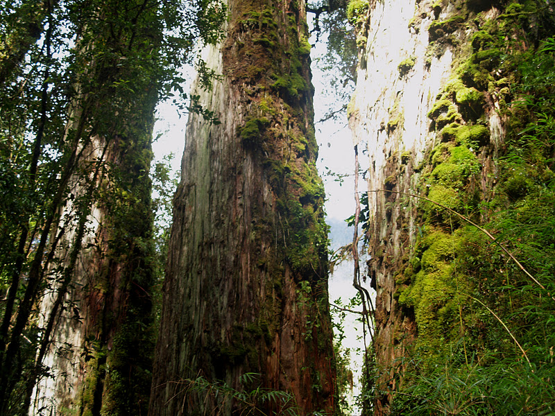
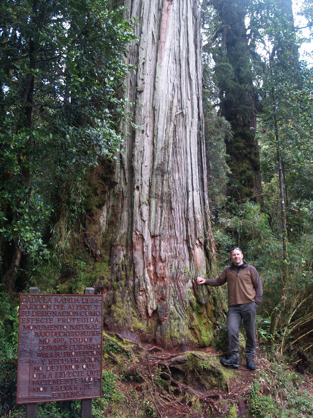
About 15 minutes’ ripio drive from Caleta Gonzalo, aside the Carretera Austral, is a magical forest of bejeweled, green giants giving a rare glimpse of how much greater the still spectacular Valdivian rainforest once was.


The Alerce pine is among the world’s oldest and most massive living things. These remarkable trees (see last blog) were once common over thousands of square miles of Patagonia; today, Pumalin Park retains about 25% of the world’s population. The Alerce Trail, along which Carlos and I are hiking, traverses the translucent, tumbling river that drains the surrounding mountains, swollen by yesterday’s heavenly outburst (today’s broken cloud and patchy blue sky are a welcome relief). I feel like a mouse crawling through a corn field as the trail weaves us around stout, towering columns in the domain of giants. The Alerces, festooned with moss, ferns and other hanging greenery, sparkle like a million fairy lights as yesterday’s captured raindrops glint in shafts of sun. Their fibrous, red-brown bark coating trunks of massive girth is similar to that of California’s sequoias, as is their slow rate of growth. Alerce timber has been sought after for decades causing the rapid decline of these trees. Their regeneration on surrounding hillsides has been stymied by frequent forest fires as witnessed by their denuded, white skeletons, frozen, grasping for the sky above the surrounding southern beeches. Thankfully the protection and restoration afforded by Pumalin’s dedicated people means that, in patches, the Alerce forest is gradually returning.


Uplifted on leaving the impressive Alerces we continue south along the Carretera Austral, Carlos pointing out features of interest on the way. Although the park is private land the Carretera running through it is a public road and, as the authorities maintain the road, they lack care over restoring the natural aesthetic and leave linear, eroding scars of bare soil and uprooted trees that line the road for miles through the wilderness. A contrast to the elegant forest experience that I have just had; come on Chile, you can do better than that!

Tuesday, 20 December 2011

Welcome to Patagonia

Poor picture of a lovely, restored building, the Pumalin Park HQ in Puerto Varas
I’ve become utterly disorientated and am struggling to determine what happens next after three days of travelling from Brazil’s central Amazon to the northern tip of Chilean Patagonia, compounding the intense experiences of the previous five weeks. I manage to hold it together enough to get to my accommodation for the night – the head office of the Pumalin Park - soon to be a new national park, in Puerto Varas. It’s late evening. My patient, kindly airport taxi driver allowed me to practice my Spanish on him as I have spent the last two weeks in Portuguese-speaking Brazil, which has returned my Spanish to square one again.

There to welcome me at the Pumalin Park office are Maria and Carolina, who has helped me make the necessary arrangements for the next section of my journey. Maria shows me around the impressive, homely building; it’s a huge, century-old, wooden house that has been restored to a high quality and with attention detail, but with a simple design. Natural materials, particularly wood, dominate and the new floorboards creak reassuringly. The refit may be recent, but the furniture is old and chunky and emits a bees’ wax scent that pervades the building. Hanging from any wall space large enough to accommodate them are impressive black and white photographs of Patagonia’s wildlife and scenery, framed in black wood. It’s a mind warp after Brazil's Amazon, but it’s a style that will become familiar and the stunning photographs dictate scenes in which I will be immersed for real in the very near future.


Carretera Austral and that funky duck!
In less than eight hours I am on the road again, waiting at the unwelcoming Puerto Montt bus station, the sun just rising and burning through the early sea mist releasing distant mountains to view. There are a couple of scruffy blokes and some stray dogs, one of which growls at a passer-by; the growl becomes a yelp after a well-aimed kick by one of the scruffy blokes. I wait with some trepidation as I’m not a big fan of long bus journeys and this one should take around 10 hours. It’s a small bus with tiny seats, but, thankfully only half full. We set off along a paved road for a few miles before it mutates to ripio (gravel road) and begins winding around a forested coastline. That will be the last paved road that I will see for some days and for a couple of hundred kilometres. A fluffy, yellow, toy duck swings in the windscreen, right in my line of sight, specially designed to test my good humour. The road we are on is renowned in Latin American travel lore; it’s the southern Chilean end of the Pan-American Highway (except it doesn’t really feel like a highway, or even a road) and is called the Carretera Austral. Over the next 10 days or so I am to become very well-acquainted with the Carretera.


Through the bus window I begin to notice wild plants familiar from my own garden and from my days at the Eden Project and its beautiful Wild Chile exhibit. Chilean Fire Bush is in full crimson bloom as are the fuchsias and the gorse – yes, the golden pride of Cornwall persists here as an introduced pest plant! We pass occasional, coastal salmon farms and sparse groups of small wooden houses surrounded by recently cleared patches of the forest. You can tell the houses are new – the corrugated metal roofs are still silvery and shiny. We wind southerly onwards flanked by steep mountains to the east, sea to the west.


Just as the ripio rattling of my body starts to affect my brain, we arrive in the tiny coastal village of La Arena nestled between a steep valley and the sea, wood smoke rising from metallic chimneys tainting the air with that familiar, homely scent. A growing queue of cars and trucks waits at the top of a concrete ramp at the other end of which are two orange ferries in the style of military landing craft. We are still waiting an hour later and I’m getting hungry since I missed breakfast and an evening meal last night. At that moment, a small local food angel jumps onto our stationery bus to dish out hot empanadas (like a small Cornish pasty, but without the Cornish) from a large polystyrene box under her arm, and sugary, black coffee from a Thermos flask.

La Arena. Our bus, the Kemelbus, is at the top of the ramp

Waiting for the tide to rise!

I wonder what we are waiting for – there are two ferries and plenty of customers. Jokingly I ask a chap in the local café if they are waiting for the tide to rise; and actually they really are. Since a recent earthquake changed the height of the land in relation to the sea around here, the jetty/ramp is now at the wrong depth at low tide ( I was given two versions of this story: some say the land rose relative to the sea, while others say it fell. They can’t both be right!).


Leaving La Arena
Someone decides somehow that the sea has reached the right depth and vehicular activity begins – at precisely the same moment that I have just bought a coffee, that I have to neck and burn my throat. Under the watchful eyes of the local sea lions vehicles are crammed onto the craft like sardines before we sail away around a spectacularly steep mountain headland that has evidently proved too much of an obstacle for local road builders. The caerulean sea is silky calm under a perfect blue sky. We traverse a deep sea fjord – the profound geological scar of a long melted glacier - and get our first glimpse of the high Andean peaks to the east.


On the other side we disembark and carry on ever southwards. Around every turn is a new vista of whatever combination of mountains, fjords, snow, forest, sea and isolated wooden shacks you care to imagine, and it’s all jaw-droppingly stunning – a view spoilt only by the incessantly swinging fluffy duck.


We emerge around a corner to the large village of Hornopiren at the foot of one of those cliched, but nevertheless impressive, snow-capped, conical volcanoes. From here we embark on a more substantial orange ferry for more than four hours of sailing to the next stretch of the Carretera. As we pull away from Hornopiren, the Hornopiren Volcano, which close-up seemed so high, appears dwarfed by the sugar-capped peaks behind, which till now had been obscured.

Hornopiren and its eponymous volcano

Cruising the line between forested mountains and islands, high waterfalls leap from precipitous, bare rock and hanging valleys tantalize with views of secret peaks. In the distance white splashes glinting in the bright sunlight indicate disturbance in the water. The disturbance moves closer until we can discern 20 or so dolphins porpoising towards us before veering off between our boat and the land and melting into the distance. Here and there, on the kinder gradients, the forest mantle has been removed and replaced with grass for cows and the occasional farm building. I wonder how anyone can make a living here; or do they just live?

Slow boat on the Pan-American Highway

On the ferry we have time to wander and chat with fellow passengers. I meet Lisi, an ecological economics professor from New York, who is travelling with Jane, a family friend and recent visitor to southern Chile. Lisi is also on her way to Pumalin Park to meet Doug and Liz, the brains behind the development of the park and many other exemplary conservation projects in southern Chile and Argentina and the main reason I am in this part of the world. On my whole journey I have met very few British people, but there are two on this ferry – Charlie and Jane – on a six-month backpacking tour of South America. They are now into month five and are also heading to Caleta Gonzalo. I also chat with a local Chilean about the area. He runs a tourist fly-fishing business on the majestic rivers further south. He explains that there are plans to replace this five-hour ferry journey – an experience of enforced relaxation and contemplation – with a new section of the Carretera bulldozed through the forests and mountains. His thought is that the most obvious and flexible way to increase capacity is to increase the number and frequency of ferries. Seems like a no-brainer to me!

Chasing the Sun on the boat to nowhere, with Lisi


Our large ferry pulls up onto a tiny ramp seemingly in the middle of nowhere. We disembark and drive up past the queue of diverse vehicles waiting to get on. I notice the first Pumalin Park signs, carved intricately from a mellow wood, at the Leptepu entrance. Another bumpy, dusty, fluffy-duck bouncing 20-minute drive later and we arrive at another in-the-middle-of-nowhere ramp into the sea. Another orange landing-craft takes us across another impressive fjord to a collection of five or six, single-storey wooden buildings, intimidated by the surrounding natural splendour, but cosily nestled at the top of a small delta beach. White wood smoke spiralling from the cabins promises a fine welcome and the end of 10 hours and 180 kilometres of ripio, sea and fluffy, yellow ducks.


Caleta Gonzalo, home for the next three nights